Palestine flag

INTRODUCTION

Palestine is located in South-West Asia and is in the heart of the Middle East. To its north is Syria and Lebanon, to its south the Gulf of Aqaba and the Sinai Peninsula, and on its east is Jordan. Historic Palestine was once a land stretching from the Mediterranean coast east across the Jordan River, and from the Gulf of Aqaba north beyond the Sea of Galilee. Today this geographical area is divided into the state of Israel (established in May 1948), and the West Bank (including eastern Jerusalem) and the Gaza Strip which Israel occupied in 1967. The struggle between the Israelis and the Palestinians is one of the most enduring and explosive of all the world's conflicts with it roots in historic claim to the land.


Palestinian tiger
Currently, the Palestinian people are being oppressed by Israel. This manifests itself in many ways; from the use of bullets and missiles against demonstrators; to the continued building of settlements with no respect for Palestinian rights; from the removal of Palestinians from their homes; to the continuos disregard for numerous United Nations resolutions.


Palestinian Intifada
Intifada is simply the defense of the Palestinian people against this oppression.
Intifada: انتفاضة Arabic word stands for shaking off or shivering because of fear or illness. It also means abrupt and sudden waking up from sleep or unconcerned status. Politically; The word came to symbolise the Palestinian uprising against the Israeli occupation. The word also stands for the weakness of the Palestinian people and their suffering under the Israeli occupation.
Intifada is simply the defense of the Palestinian people against this oppression.


The Gaza Strip was established at the end of the 1948 Arab-Israeli war. Its boundaries were defined by the ceasefire lines. It was placed under Egyptian rule and held in trust for a future Palestinian state.
At the end of the 1956 Suez-Sinai War, the Gaza Strip was occupied by Israel. A year later Israel withdrew its troops as a result of international pressure and a United Nations Emergency Force (UNEF) was placed in the Gaza Strip.
In June 1967, Israel recaptured the Gaza Strip during the Six-Day War. In November of the same year UN Security Council Resolution 242 called on Israel to withdraw from the Gaza Strip and other ‘occupied territories.
Gaza is an arid rectangle of territory at the southeast end of the Mediterranean. 45 km (25 miles) long and 10 km (6 miles) wide, it is wedged between Israel to the north and east, and Egypt’s Sinai Peninsula to the south. The Gaza Strip is one of the most densely populated places on earth with 3,823 persons per km2. The population of Gaza tripled in 1948-49 when it absorbed approximately 175,000 Palestinian refugees fleeing their homes in what is now Israel. There are now about 1.5 million inhabitants in the Gaza Strip. The majority of the population is young refugees: the average age in the Gaza Strip is 16.


Palestinian children


Iraq flag


Basic facts of Iraq


Official name : Republic of Iraq

Capital : Baghdad

Area : 438,317 sq km 169,235 sq mi

Population : 28,221,181 (2008 estimate)

Religious affiliations : Muslim 96 percent

Shia : 60-65 percent

Sunni Muslims : 31-36 percent

Christian : 3 percent

Other : 1 percent


Introduction:

Iraq, country in the Middle East that has been central to three wars since 1980. Some of the world’s greatest ancient civilizations—Assyria, Babylonia, and Sumer—developed in the area that now makes up Iraq. The modern state of Iraq was created in 1920 by the British government, whose forces had occupied it during World War I (1914-1918). The country is officially named the Republic of Iraq. Baghdad is the capital and largest city.Iraq is situated at the northern tip of the Persian Gulf. Its coastline along the gulf is only 30 km (19 mi) long. Thus, the country is nearly landlocked. Its only port on the gulf, Umm Qaşr, is small and located on shallow water, and only small craft can dock there. Iraq was potentially one of the richest countries in the world. It contains enormous deposits of petroleum and natural gas. It is endowed with large quantities of water, supplied by its two main rivers, the Tigris and the Euphrates, and their tributaries. Iraq’s location between those two great rivers gave rise to its ancient Greek name, Mesopotamia (“the land between the rivers”).Most of Iraq’s people are Arabs. IraqIran, resulting in a costly war in the 1980s. At times it has claimed neighboring Kuwait, most recently in 1990, leading to the Persian Gulf War in 1991. IraqIraqIraq’s regional and foreign policies were ambitious, often involving great risk. In the late 20th century Iraq attained a high international profile, unprecedented in the modern history of the Middle East, but at an exorbitant political price. The dictatorship failed in various attempts to topple Arab regimes and to achieve leadership status in the Arab world or even in the Persian Gulf region. It failed in eight years of war in the 1980s to bring down the regime of neighboring Iran. It conquered Kuwait in 1990 but was forced to relinquish it by a coalition of Western and Arab countries in the Persian Gulf War. Afterward, it found itself shackled by an oil embargo and other sanctions imposed by the United Nations (UN). A United States-led invasion overthrew Hussein’s regime in April 2003 . Hussein was captured and executed, and a new Iraqi government was formed. However, an insurgency developed in resistance to the U.S. occupation, and sectarian conflict resulted in what many observers called a civil war.


Saddam Hussein

Saddam Hussein became president of Iraq in 1979. He created an international crisis in 1990 when his army invaded Kuwait. The invasion was condemned by the United Nations (UN), which initiated a trade embargo and, later, a military campaign against Iraq. Hussein was overthrown in 2003 by an invasion led by the United States. on December 30, 2006 Saddam Hussein has been given hanged on December 30, 2006.


The execution of Saddam Hussein took place on December 30, 2006. He was sentenced to death by hanging, after being found guilty and convicted of crimes against humanity by the Iraqi Special Tribunal for the murder of 148 Iraqi Shi'ite in the town of Dujail in 1982, in retaliation for an assassination attempt against him.


On December 31, 2006, Saddam Hussein's body was returned to his birthplace of Al-Awja, near Tikrit, and was buried near the graves of other family members.


Saddam Hussein photo before his execution


US-Iraq war : A US-led coalition invaded Iraq in March 2003 with the aim of overthrowing the regime of Iraqi leader Saddam Hussein.


Military Attacks on Iraq


United States forces fire at Iraq.


Bombing of Baghdad

In March 2003 a military coalition led by the United States invaded Iraq with the goal of removing Iraqi president Saddam Hussein from power and destroying Iraq’s alleged stockpiles of banned weapons. The invasion was accompanied by strategic bombing strikes at military and leadership installations in the capital city of Baghdād

and other Iraqi locations. By mid-April, Hussein’s government had collapsed.


Fighting in Al Fallujah

In late 2004 U.S.-led forces launched an offensive against insurgent strongholds in the Iraqi city of Al Fallujah, west of Baghdad. An estimated many insurgents and 51 U.S. troops were killed in the three-week operation, which destroyed large parts of the city.


Destroying Nuclear Facilities

Nuclear facility in Al Tuweitha near Iraq’s capital of Baghdad. The facility was destroyed by the International Atomic Energy Agency (IAEA) after the Persian Gulf War to prevent Iraq from reconstituting a nuclear weapons program under the regime of Saddam Hussein.


Some Iraqi children photos


Bangladeshi flag

Basic Facts of Bangladesh
Official name: People’s Republic of Bangladesh
Capital: Dhaka
Area 147,570 sq km, 56,977 sq mi
Population density: 1,147 persons per sq km, 2,970 persons per sq mi (2008 estimate)
Urban/rural distribution:
Share urban 25 percent
Share rural 75 percent (2005 estimate)
Largest cities: Dhaka, Chittagong, Khulna, Rajshahi, Narayanganj.
Languages: Bangla (official), Urdu, English
Religious affiliations:
Muslim 86 percent
Hindu 12 percent
Other 2 percent
Life expectancy:
Total 63.2 years
Female 63.3 years
Male 63.1 years (2008 estimate)
Literacy rate:
Total 44.2 percent
Female 33 percent
Male 54.9 percent (2005 estimate)
Form of government: Republic
Total number of military personnel 125,000 (2004)

Introduction:
Bangladesh, in full, People’s Republic of Bangladesh, republic of southern Asia, in the northeastern portion of the Indian subcontinent, bordered on the west, north, and east by India, on the southeast by Myanmar (formerly known as Burma), and on the south by the Bay of Bengal. The area of the country is 147,570 sq km (56,977 sq mi). The capital and largest city of Bangladesh is Dhaka.


Dhaka city
Dhaka is capital of Bangladesh .Founded in 1608 as the Seat of the Imperial Mughal Viceroys of Bengal and known the world over for centuries for its fine silk and muslin, Dhaka as the capital of Bangladesh has grown into busy city of about four mi lion people.Having a happy blending of the old and new architectural trends, Dhaka has been developing fast as a modem city since 1982 and is throbbing with activities in all spheres of life, be it industrial, commercial, cultural or political. Dhaka is home to over 4 million people and covers about 816 square kilometers. The climate is tropical as in the rest of Bangladesh; for most of the year it is warm with bright sunshine, but during the Monsoons there's heavy rainfall. During the winter months (November to March) it is cool and pleasant.


Baitul Mukarram – The National Mosque of Bangladesh
The national mosque of Bangladesh, Baitul Mukarram, is situated in the heart of the busy city of Dhaka, the capital of Bangladesh.Followers of the Islamic faith consider a mosque to be the primary place of worship where Muslims gather together for prayer. Mosques reflect traditional Islamic architecture and are recognized world-wide for their importance to the Muslim community. In addition to the importance mosques have with regard to worship and prayer, they also serve as places to learn about Islam and to meet fellow believers. The Baitul Makarram Mosque Society was established in 1959 to oversee the project. The land that was selected for the mosque complex is close to the central business district of the city and easily accessible. The mosque complex of Baitul Mukarram was designed by the architect T Abdul Hussain Thariani and has several modern architectural features, while still beautifully preserving the traditional principles of mosque architecture.


Chittagong city
Chittagong is the port city with a population of 1,750,000 (1986 est.). It is the commercial and manufacturing center of Bangladesh. Situated on the Karnaphuli river some 19 km (12 mi) from its mouth at the Bay of Bengal, it is the chief port of the country. It provides an extensively developed port facilities for ocean steamers. An ancient city, Chittagong passed from Tippera (Buddhist) dominance to Arakan (Hindu) and then Mogul (Muslim) rule, with periods of re-conquest and re-control. The Portuguese made inroads in the 16th century, and the British gained control in 1760. Industries powered by a hydroelectric plant up the river, use the products of the area--jute, cotton, rice, tea, petroleum (from offshore installations), and bamboo. The bamboo is harvested chiefly from the Chittagong Hill tracts. 13,191 sq km (5,093 sq mi) of rugged, thickly forested land along the Bay of Bengal is inhabited by primitive mountain tribes.

Chittagong port
Chittagong, the leading port of Bangladesh, lies on the banks of the Karnaphuli River near the Bay of Bengal. A Portuguese trading center in the 16th century, Chittagong was under the jurisdiction of Britain, Burma (now known as Myanmar), and Pakistan before becoming part of Bangladesh in 1971.


Traditional Bungalow of Bangladesh
Most rural houses in Bangladesh are constructed with bamboo and have thatched roofs. This house is a typical Bangla.


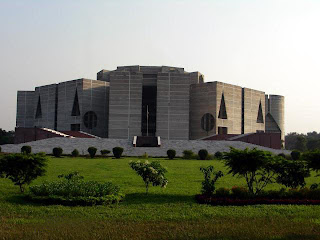
Parliament Building, Dhaka
Dhaka, the capital and largest city of Bangladesh, is an important commercial, manufacturing, and government center. The Parliament building, shown here, was designed by American architect Louis I. Khan.


Some Bangladeshi children photos


Pakistani flag

Basic facts of Pakistan
Official name: Islamic Republic of Pakistan.
Capital : Islamabad.
Area : 796,095 sq km 307,374 sq mi
Population : 167,762,040 (2008 estimate)
Government:
Form of government: Republic.
Head of state : President.
Head of government : Prime minister.
Religious affiliations:
Sunni Muslim : 77 percent.
Shia : 20 percent.
Christian, Hindu, and other: 3 percent.
Population density: 215 persons per sq km, 558 persons per sq mi (2008 estimate)
Urban/rural distribution: Share urban 35 percent, Share rural 65 percent (2005 estimate)
Largest cities, with population:
Karachi 9,339,023 (2006 estimate), Lahore 5,063,499 (1998), Faisalabad 2,510,000 (2007 estimate),Rawalpindi 1,406,214 (1998), Hyderabad 1,390,000 (2007 estimate)
Languages: Urdu (official), English (commonly used), Punjabi, Sindhi, Pashto, Balochi, Saraiki
Life expectancy:
Total 64.1 years,
Female 65.2 years,
Male 63.1 years (2008 estimate)
Literacy rate:
Total 47.4 percent,
Female 32.4 percent,
Male 61.4 percent (2005 estimate)
Total number of military personnel 619,000 (2004)

Introduction:
Pakistan, officially Islamic Republic of Pakistan, republic in South Asia, marking the area where South Asia converges with Southwest Asia and Central Asia. The capital of Pakistan is Islamabad; Karachi is the country’s largest city. The area of present-day Pakistan was the cradle of the earliest known civilization of South Asia, the Indus Valley civilization (2500?-1700 bc). The territory was part of the Mughal Empire from 1526 until the 1700s, when it came under British rule. Pakistan gained independence in August 1947. It initially comprised two parts, West Pakistan and East Pakistan, which were separated by about 1,600 km (1,000 mi) of territory within India. In December 1971 East Pakistan seceded and became the independent republic of Bangladesh.


Faisal Mosque, Pakistan
Islamabad A planned city, Islamabad replaced Karachi as Pakistan’s capital in 1967. The city contains many examples of modern architecture, including Faisal Mosque, designed by Turkish architect Vedat Dalokay.


Pervez Musharraf
General Pervez Musharraf became de facto leader of Pakistan after staging a military coup in October 1999 that ousted the unpopular Prime Minister Nawaz Sharif.


Hindu Kush Mountains, Pakistan
The Hindu Kush mountain system in central Asia extends for 1,000 km (600 mi) in parts of Afghanistan, Pakistan, and Tajikistan. With about two dozen peaks surpassing 7,000 m (23,000 ft), the range reaches its highest point in Pakistan’s highlands, where the peak known as Ti rich Mir rises 7,690 m (25,230 ft) above sea level.


Peshawar, Pakistan
Pakistan Located near the strategic Khyber Pass connecting Pakistan and Afghanistan, Peshawar has been an important trading center since ancient times. It became the capital of Pakistan’s North-West Frontier Province in 1947.


Pakistani Muslims
A Muslim prays outside the entrance of his home in Quetta, in northwestern Pakistan. About 97 percent of the people in the country are Muslims, of which about 80 percent are Sunni Muslims.


Some Pakistani children photos


Pakistani Muslim woman

Afghan flag

Basic facts of Afghanistan

Official name: Transitional Islamic State of Afghanistan,
Capital: Kabul,
Area 652,225 sq km, 251,825 sq mi,
Population: 32,738,376 (2008 estimate),
Population density: 51 persons per sq km (2008 estimate)131 persons per sq mi,
Share urban 23 percent (2003 estimate),
Share rural 77 percent,
Largest cities, with population:
Kabul : 2,956,000 (2003 estimate),
Kandahār: 225,500 (1988 estimate),
Herāt: 177,300 (1988 estimate),
Languages:
Afghan Persian (Dari),Pashto,Turkic languages (primarily Uzbek and Turkmen) minor languages (primarily Baluchi and Pashai),
Religious affiliations:
Sunni Muslim 84 percent
Shia 15 percent
Other 1 percent,
Life expectancy :
Total 44.2 years (2008 estimate)
Female 44.4 years & Male 44 years

Introduction:
Afghanistan, a country in southwestern Asia that is situated on a landlocked plateau between Iran, Pakistan, China, and several countries in Central Asia. Afghanistan is a rugged place. Rocky Mountains and deserts cover most of the land, with little vegetation anywhere except the mountain valleys and northern plains. The country has hot, dry summers and bitterly cold winters. Kābul is the capital and largest city.


Kabul, Afghanistan
Kabul, Afghanistan’s capital and largest city, sits at an elevation of about 1,795 m (5,890 ft) in the Safed Koh mountain range. The city occupies the main approach to the Khyber Pass, an ancient trade route linking Afghanistan with Pakistan.


Friday Mosque in Herat
The 800-year-old Masjid-i-Jami, or Friday Mosque, dominates the old section of Herat, western Afghanistan's largest city and the capital of Herat. Four blue minarets frame the striking blue and white mosque. In recent decades this ancient town has become an international shipping hub, taking advantage of its strategic location near Iran and Turkmenistan.


Afghan Women Shrouded in Burkas
These Afghan women in Herat, northwestern Afghanistan, are wearing full-length veils called burkas. Wearing the burka is part of the ancient custom of purdah, which requires the concealment of women from men. Purdah was revived in recent times by Islamic fundamentalist movements such as the Taliban, which held power in Afghanistan from 1996 until late 2001.


Taliban Troops on the Kabul Front
Taliban forces patrol the front north of Kabul, Afghanistan, during the civil war that ravaged the country in the 1990s. The civil war was fought between the Taliban, an Islamic fundamentalist movement composed of ethnic Pashtuns, and the Northern Alliance, a coalition of several minority ethnic groups. The Taliban seized control of Kābul in 1996 and controlled most of the country until 2001. Now they are fighting against American forces & coalition forces for Islamic state.


Afghan Sport of Buzkashi
In the town of Mazar-e Sharif, dust clouds almost obscure riders as they play a wild game of buzkashi, a traditional sport popular with the northern ethnic groups of Afghanistan. Buzkashi is played on huge fields-about 2 kilometers (about 1.2 miles) long-by two teams of chapandoz, or riders. The object of the game is to transport the boz, the headless body of a calf or goat, from one end of the field to the other. Because the competitors are known to do almost anything to prevent the boz from being moved, the game is very rough.


Some afghan children photos